Showing posts with label Millcreek Canyon. Show all posts

Friday, December 19, 2014

Church Bells in Rattlesnake Gulch?! (Easy 1.5 miles round trip hike)


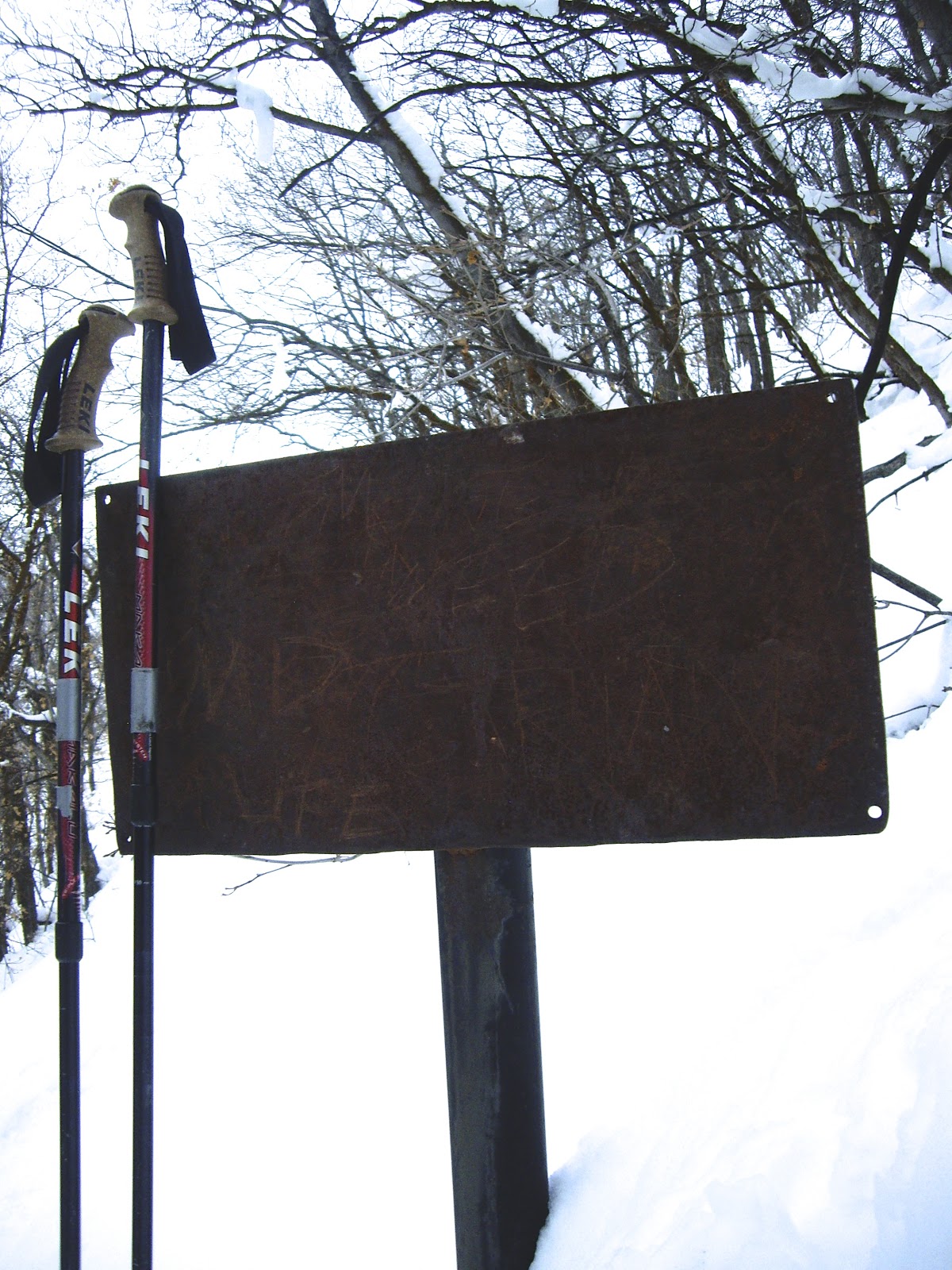
 Here it is almost Christmas, and there is still not enough snow to snowshoe, but my trekking poles were begging for a hike, and I wanted to try out my new "Icetrekker" boot chains that I picked up on sale at REI for $13.99.  I have done this hike at all times of year, and winter is my favorite. OK, there are not actually  church bells in Rattlesnake Gulch, but there is an old metal sign at about 3/4 mile that sounds exactly like a church bell when you throw a rock at it or hit it with your trekking pole.  It sounds really cool, and reverberates for about 20 seconds.  One advantage of hiking solo, is that I can ring the gong for as long as I want to!  I want very much to know if it can be heard from the trail head!
The "gong" sign

     The trail head is just under one mile from the pay booth in Millcreek Canyon. (If you don't have an annual pass, and you hike early, nobody is in the booth, and you will save the  $2.25 fee on your way out.) The trailhead is on the left side of the road, a very wide area with a sign and room for several cars to park. I was surprised that I was the first car to arrive, but I guess I should not be so surprised, because it was still quite dark!  You almost never need snow shoes on this trail, as it gets packed down quickly, but you should have some kind of  cleats or chains on your boots/shoes.  On my way back down, I saw a mom carrying a baby in a baby back pack, and all she had on her feet were plain old running shoes; kind of scary!
     The trail starts out at a slight incline, then steepens into some long switchbacks. After about 15 minutes you will come to a T in the trail. Go to the left to get to the gong, and the Salt Lake Valley overlook.  A few more switchbacks, and you will be on a level trail the rest of the way. At 3/4 of a mile from the trailhead, you will see the rusty but sturdy sign on your right. Go ahead, hit it a few times; The gong sounds long and clear in the cold, dense mountain air!  I continued on the trail another mile to a great view of the valley, then nabbed a geocache on my way down:
http://www.geocaching.com/geocache/GC3C8GF_pipearazzi?guid=2f99b815-6304-4b9b-93e5-cb460d6496e9
     So, this was a successful little winter hike as my trekking poles and I got a good workout, my new boot chains worked well, I found another geocache, and best of all, I got to ring the gong in the cold mountain air!  Is anybody up for a New Year's Eve hike up Rattlesnake Gulch to ring in the new year?


Turn left at this sign


View of Salt Lake Valley

A cool  large rock at base of switchbacks

"Icetrekker" boot chains

Saturday, March 9, 2013

Pipeline Trail Burch Hollow to Elbow Fork

This is another Millcreek Canyon snowshoe hike. Since it is a South-facing trail, the snow is disappearing quickly in spots.  The hikes starts 3.8 miles past the toll booth. Park on the left side of the road. (The Burch Hollow sign is on the right side of the road just before the parking area). Head up the trail. It is not particularly steep.  After about 1/2 mile, you will get to a sign giving you the option to head left toward the Grandeur Peak Trail or right to Elbow Fork. The sign says it is 2 miles to Elbow Fork, but this is way off!  It is actually 3.23 miles to Elbow Fork, or about 2.75 miles from this sign!  The entire hike from the parking area to Elbow Fork is only a 750 feet gain in elevation, so not bad at all.  There are some nice big pine trees, especially at the beginning and at the end of the trail.  When I arrived at Elbow Fork I hiked back down the road to my car.  The total hike was 5.15 miles and took a leisurely 2 1/2 hours. I wore a light jacket but took it off at the .5 mile point.  Things I pondered about: What percent of dog owners do not clean up after their dog?  My guess is 5%.  That adds up to a lot of mess.  Why can dog feces be smelled from 50 feet away, but deer scat is odorless at 3 feet away?  (Carnivore diet?)

Trailhead

Looking across the canyon to the Terraces road.

Sign at .5 miles with incorrect mileage info.

Sign at about 2 mile point. I want to explore this trail soon.

Plenty of deer scat around.

Getting close to Elbow Fork

My trekking poles taking a rest at Elbow Fork

Looking down at skiers almost to Elbow Fork

Saturday, February 23, 2013

Rattlesnake Gulch to Church Fork


This is another Millcreek Canyon hike that starts about one mile past the toll booth. Park on the left side of the road and head up Rattlesnake Gulch. At .7 miles there is a sign for the Pipeline Trail. Go to the right. From this point, there will be some more switch backs, then the trail is easy and quite level. You will have a nice view of the Boy Scout Camp, Camp Tracy.  After a couple of miles, the trail will drop down into a gorgeous area of large pines.  At this point you will see a sign pointing to the trail to Grandeur Peak to the left, but I went down to the right and through the Church Fork picnic area. When you get down to the main road of Millcreek Canyon, you will have gone 3.3 miles. From this point I took off my snowshoes and hiked down the road to my vehicle. This was 1.7 miles, and I had gone exactly 5 miles total.
A large fin of rock just before the switchbacks begin.
I was told it is a remnant of an ancient stream bed.

Along the Pipeline trail

It snowed the entire hike, but the sun
peaked out occasionally.

I went to the right today.

One more chance to go to the left.

I just couldn't stop taking pictures
on this gorgeous snowy day!

Remnants of pipeline straps.

For some reason I had a hunger for raw carrots
after seeing these icicles.

An apparent alien buried in the snow!

Getting close to Church Fork

Glad I had my sunglasses today

Top of Church Fork area

This sign tells about mining claims donated
to the Boy Scouts in 1919. 

Friday, February 1, 2013

Rattlesnake Gulch Snowshoeing

This morning I drove up Millcreek Canyon, just under one mile from the pay booth. I parked on the left side of the road near a sign that said Pipeline Trail.  It was still dark, so I took my time putting on my snowshoes, so I would not have to use my headlamp.  I headed up the gulch following some large switchbacks on a moderately steep trail.  I remember hiking this trail with Lizzy one summer, and we took a "shortcut" that was almost impossibly steep and difficult to get up. It took us near a cave entrance that smelled very strongly of dead animal, and we did not go in there, not only due to the odor, but due to the fact that this is mountain lion country, and I suspected that may be a mountain lion den.  I  stayed on the main trail today, but saw mountain lion tracks in the snow crossing the main trail toward the cave.    About .7 miles up the gulch I came to a sign pointing to Grandeur Peak to the right, and Pipeline Trail to the left. I went to the left. At this point the trail levels out and follows the old pipeline bed. There are a few pieces of pipeline fittings along the way. There is also a very sturdy old metal sign with the lettering long-gone. Perhaps it said, Do Not Walk On Pipeline?  The cool thing is if you hit it with your trekking pole, it sounds a great gong, exactly like a church bell!  You can hear it reverberating for about 20 seconds.
     As I continued along the trail, the sky was gorgeous in the East with the rising sun.  Just as I rounded a curve in the trail, the sun struck the Oquirrh Mountain peaks across the Salt Lake Valley, illuminating Kennecott Copper Mine.  The entire hike took me about 2 hours and was 3.5 miles long.

Map at trailhead

Trekking poles resting after steep hike

trekking poles had a competition
to see which could make the
loudest gong!

Still dark enough to see the waning moon

I saw 7 mule deer

rounding the curve

Kennecott Copper Mine to the West

Sunrise in the East

Interesting geological formations, look like geodes

Friday, December 21, 2012

Terraces to Elbow Fork Snowshoe Hike

Sign at top of Terraces picnic area
 Today I had a gorgeous snowshoe hike in Millcreek Canyon.  I drove about 3.8 miles up the canyon (from the fee booth) and parked on the left side of the road across from the Terraces picnic area.  You can get to Elbow Fork by going up the road about 1.5 miles from this point, but I took the long scenic route, which made it just over 3 miles to Elbow Fork.  I followed the road up to the top of the Terraces picnic area. This is only about 1/4 mile, but it gets your heart beating, as it is pretty steep. Just past the restrooms (they are locked), you will see a trailhead sign. If you go to the right, you will go to Bowman Fork, which I have done before. But today I went to the left. It is level and easy at first. Then it goes up some fairly steep switchbacks up to a ridge. I was glad others had made tracks before me, as I am not sure I would have been able to stay on the trail with this much  snow.  It was fun to be on a hike where I actually needed snowshoes.  The view from the ridge is fantastic.  You can see down into Porter Fork, down into the Salt Lake Valley, and you can see across Millcreek Canyon where the pipeline trail runs. The ridge has many ups and downs, but is fairly easy.  There is one spot where you have to climb over a rocky spine, but there is nothing dangerous or difficult, and there are no areas where you need to worry about avalanches.  At the top of the ridges, you finally go down some switchbacks to a bridge near Elbow Fork.  I did not start hiking until 1 PM, and went a leisurely pace, taking lots of pictures. It took me 1 3/4 hours to Elbow Fork, then 35 minutes to go down the road to my car.  I saw a lot of deer tracks along the way, and one set of moose tracks.  I was glad I remembered sunscreen and chapstick, which I often forget. I wished I had worn my gaiters, as I kept getting snow down my boots.  I also wish I had brought my thermometer, as I wondered what the temperature was. It was 24 degrees in the valley, and a bit cooler in the mountains, although I was plenty warm with just a light jacket and gloves. I brought a hat but did not wear it.  Many people were bundled up like Eskimos.
     The weather could not have been more perfect.  Along the way, I remembered that today was the day some people thought would be the end of the world (The end of the Mayan Calendar).  I decided that if this were the end of the world, other than having my family with me, I could not think of a better way to spend a last day!  I did this hike again on Dec 29 with two of my sons and a nephew. The day was gorgeous again, and we placed a geocache on the ridge.
See http://www.geocaching.com/seek/cache_details.aspx?guid=17d63d13-6bf0-4460-865a-51f70f595604.
Looking across canyon toward Mount Aire

View of Salt Lake Valley and back of  Grandeur Peak
Daniel, Jake and Tyler

A rare photo of myself in my blog (since I am usually behind the camera), between Daniel and Jake

Where we hid the geocache

My trekking poles resting next to the amazing alpaca wool hat
my Sweetie knitted for me.

A level part of the trail

Hiking along the ridge

Almost to Elbow Fork

Sun filtering through pines

Friday, November 23, 2012

Millcreek Canyon Snowshoe Hike to Yurt

The Yurt

An interesting "bug-eyed" bug out for a stroll

This is why I love snowshoeing!
 I did this hike November 16. It starts about 5 miles up Millcreek Canyon, which is as far as you can drive this time of year. It is almost 10 miles round trip to hike to the yurt and back. It took me 2 1/2 hours to go up, take pictures, etc. and about 1 1/4 to go back down at a brisk pace, even running a bit. You can rent the yurt from the Forest Service. It has a wood stove, all the firewood you need, and even restrooms near by. It sleeps 6 to 8 people. I want to try that sometime!  There was only one car in the lot when I started up at 7 AM.  I met this person at about the 3 mile mark, and she was cross-country skiing down with SIX dogs!  By the time I got back to the parking area, the lot was full of cars.
 More people ski this than snowshoe it, but there are a couple of
steep icy runs that I don't like, so I usually just snowshoe.  Many people just wear boots or running shoes, as it is usually well-packed and groomed.  I was pleasantly surprised at the amount of snow for this time of year; the road was completely covered.  One thing you don't want to do is dress too warmly, as it doesn't take long to work up a sweat. Layers of clothing is the way to go.  This was my first time out snowshoeing this year, and I forgot to bring my coat, but I
didn't need it. I was fine in my Underarmor shirt and pants.  The gloves were nice to have, though. I bought them at Recreation Outlet a while back on sale for about $5!   I saw tracks from a large moose, and a smaller one, that were made that morning. (No ice crystals formed in the prints, and the prints were very well-defined, and no frozen crust of snow in the prints.)  Several years ago we saw a moose in this canyon on our way up to snowshoe. We stopped our car and watched it, and several cars stopped behind us. A delivery truck was on the way down the canyon. The driver honked his horn, and when the moose did not move, he got out of his truck and tried to shoo it off the road by waving his arms. I wish I had gotten it on video! You CANNOT shoo a moose! The moose charged him, and with terror in his eyes, he jumped back in his truck!  Now the moose was mad, and it charged toward my Expedition. I guess the Expedition was larger than it wanted to tangle with, so it turned away, and instead charged the cute little red Volkswagon Jetta right behind us.  The moose kicked it several times, causing the two girls inside to scream loudly.  I'll bet that was an interesting insurance claim.  I took a picture of the moose with its tongue hanging out, and the Salt Lake Tribune published it  with the above story.  Anyway this is a fun hike with lots of options to go on side trails that I will blog about in the future.  If I had to have a dog, I would definitely bring it along on this hike (but only ONE dog, not SIX!)

Update 12/7/12   Andy and I drove up Millcreek Canyon this morning, driving very slowly where I slid off the road (see comments), and we hiked up to the yurt. We made good time, one hour, 45 minutes, without snowshoes.  Much of the snow had melted and there were many icy spots and bare spots on the road.  It was a beautiful day for a hike.  (But to me, ANY day is a beautiful day for a hike!)  The yurt was occupied this time, and seemed cozy with smoke coming out the flue.  We saw the lady with the six dogs that I had seen last time. She seemed happy as she was going back down, but as we were hiking down, we saw her going UP again, with only four dogs and no smile on her face, as two of the six dogs were running away from her.

Sun Just appearing about 8:15

I obeyed this sign after 2 hours of snowshoeing.

Trekking poles happy to wear snow baskets

These mittens are great for easy access to fingers for taking pictures or using GPS

At the 1.25 mile mark

The fog burning off to reveal a gorgeous day (12/7/12)

Me at the yurt on 12/7/12