Sunday, May 31, 2015

South Willow Lake (8 miles round-trip, moderate difficulty)

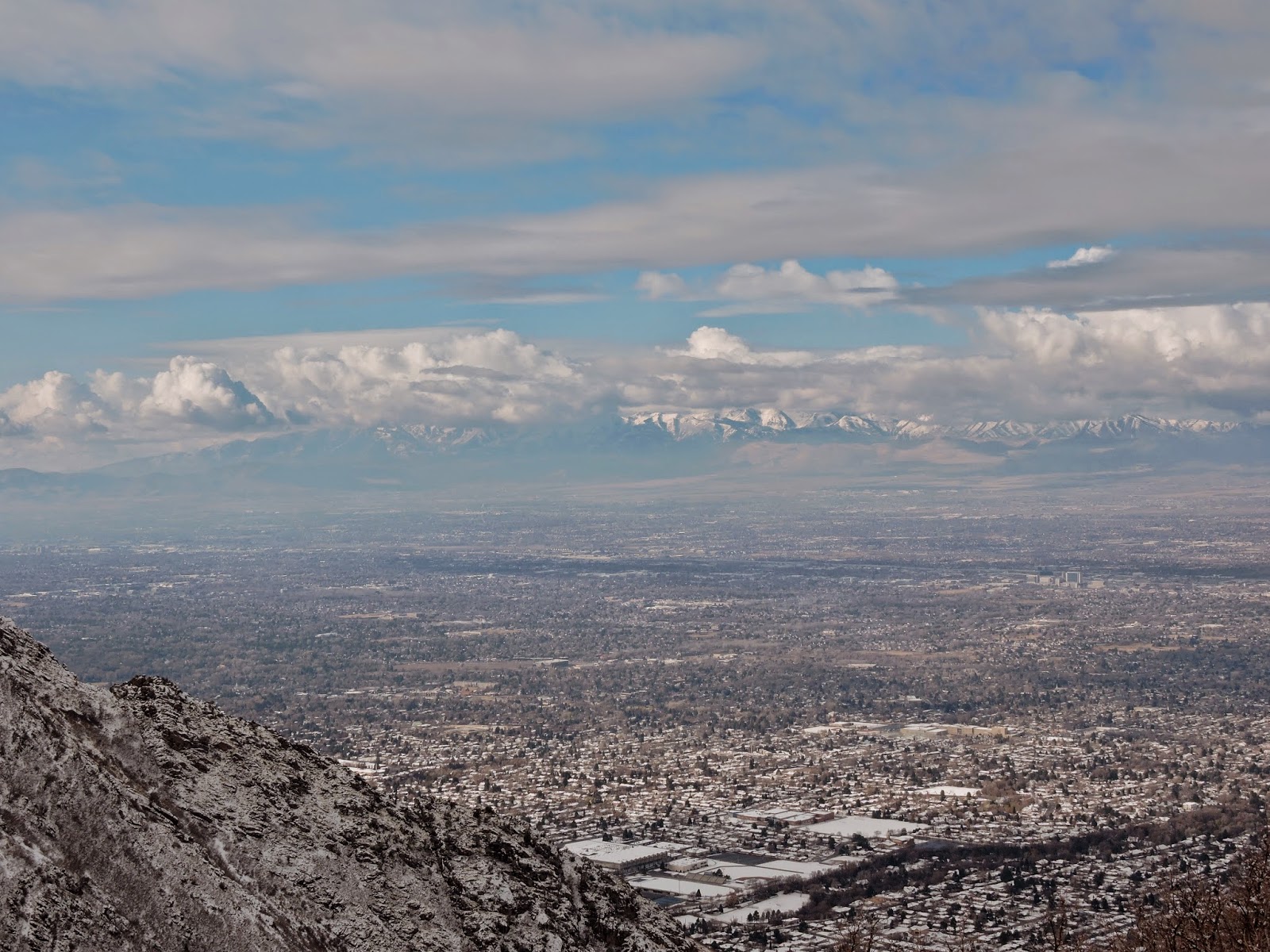
     My brother and I had intended to hike to Deseret Peak, but the road to the trailhead was closed due to a rock slide, with threats of a $5000 fine for entering the area, so we parked at another trailhead, started doing some geocaches, noticed a small lake on the gps map, and ended up at this beautiful alpine lake with an elevation high enough to look over the Ocquirrh Mountains and see Twin Peaks, Lone Peak, etc. in the Wasatch Mountains.

Directions:     To get to the trailhead from Salt Lake City, take I-80 West to the Grantsville Exit (Exit 84). Head to Grantsville on UT138 for 9.5 miles.
Turn right on 400 West and continue for 5 miles to South Willow Canyon.
Go West on South Willow Canyon road  for about 5 miles to a place where a Boy Scout Camp is to the left, the gate (closed, in our case) that leads to the loop campground is straight ahead, and the Medina Trailhead is to the right.
Turn right, and go a very short distance up a hill and park at the Medina Trailhead.
(gps coordinates  N 40* 29.754' W 112* 34.618')
The trail starts to the right of the outhouse.
 Follow this trail, and after about 1/3 of a mile, you will come to an old mining road.
 (gps coordinates N40* 30.160' W112* 34,787')
Turn left (West) and follow this road which becomes a trail as it enters the Deseret Peak Wilderness Area.
Enjoy the beauty as you ascend for a few miles, and don't forget to look back occasionally at the view of Tooele Valley behind you!
You will arrive at a wooden trail sign (gps coordinates N 40* 29.541' W 112* 37.130').
 Follow the trail to the right that leads to South Willow Lake.
 
     The lake is at the base of the steep cliffs. We went off trail in places to avoid some deep soft snow.  The lake is small but beautiful, and a great place to take a rest.
Near the lake is an incredible spot with a rock campfire ring, where you can look West at the lake and feel like you are deep in the wilderness, or look East at the Tooele Valley, and see the beautiful Wasatch Range in the distance, above the Oquirrh Mountains.
We went back down the way we came.
Our gps said we had gone 7.8 miles, so we continued down to the Boy Scout Camp to find another geocache, to make this an 8 mile hike, almost the same distance as the hike to the top of Deseret Peak will be once the road is open!  

     Geocaches I found were: 
Medina Trail Cache:http://www.geocaching.com/geocache/GC305TJ_medina-trail-cache?guid=e910f185-419c-4057-8857-e68fac0c485b,
Take a Break: http://www.geocaching.com/geocache/GC4BXWB_take-a-break,
By the Boy Scout: http://www.geocaching.com/geocache/GC3GFAK_by-the-boy-scout
The lake is at the base of the cliffs about 3 miles ahead.

Entering Deseret Peak Wilderness Area.

South Willow Lake still a bit icy.

View from the lake with the Wasatch Mountains behind the
Oquirrh Mountains.

View from Mormon Trail Road, about 8 miles from
the lake. South Willow Lake is at the base of the
large snow area.


Sunday, May 17, 2015

Parrish Canyon Trail (Easy, 5 miles roundtrip)

     This was the "Hike of the Week" a couple of weeks ago in the Salt Lake Tribune.
 This is a fun, relatively easy hike that you can do with dogs or  mountain bike, with lots of wildflowers, and the destination of a beautiful meadow or  a very nice fire ring with plenty of firewood and a place to sit and enjoy the view!

     The weather has been so rainy that I had not hiked for a couple of weeks. Rain was forecast again, but I woke up early, peeked outside, and it was not yet raining, so I decided to go for it.

Directions:  Drive North on  I -15 from Salt Lake City, and in less than 20 minutes, take the Parrish Lane Exit and head East. At the top of Parrish Lane, turn left on a narrow paved road that takes you to the trailhead (gps coordinates N 40* 55.337' W 111* 51.970').

The Hike:  There is a large wooden trail sign on the North end of the parking area. This is the beginning of the trail.  At .15 mile keep going straight across the firebreak road.  Follow switchbacks up the mountain. At times you will see and hear waterfalls from Parrish Creek on your North.  Be sure to take frequent rests and admire the great view of the Great Salt Lake and Antelope Island.  At about 1.7 miles you will come to a fork in the trail. Either one will work, but I stayed to the right, which provides the best view of a rock outcropping that looks like the profile of a dog's face.  Just past the dog face, the trail steepens and fades, but soon rejoins the main trail that you would have been on if you had taken the left fork.  At just over 2 miles, you come to a beautiful meadow rimmed with Mountain Mahogany trees, and a beautiful view of a canyon of pine trees. But don't turn around yet, keep going for another .4 miles and you will be rewarded with a great resting area complete with a very nice fire ring, places to sit, and plenty of dry firewood  to roast marshmallows and make S'mores!  (The gps coordinates are: N 40* 55.339' W 111* 50.598')

      I was sorely tempted to start a campfire, but the promised rain was arriving, so I  headed back to the car, but made a mental note to make this an evening hike sometime, and roast marshmallows before returning by the light of the moon or headlamp!  I had not loaded Geocaches into my gps but had scribbled the coordinates of one that I thought would be near the trailhead, so I found that one before heading back home.

Geocaches I found:
 WizMedic's Quickie Cache UT: http://www.geocaching.com/geocache/GCMTQW_wizmedics-quickie-cache-ut?guid=8c305fb0-2cc2-4987-a2de-91d02f16eeee
Trailhead Sign

Great views for most of the hike

Parrish Creek

Can't get enough of the view!

Vibrant wildfolwers

Dog Face Rock

Mountain Mahogany and Meadow

Fire Ring. A good Destination!

Saturday, April 25, 2015

Holbrook Canyon 6 miles round trip, Easy to Moderate Difficulty

I read about this nice hike in yesterday's Salt Lake Tribune. It is the "Hike of the Week."
It is scenic, fun, and you can make it longer or shorter, depending on how much time and energy you have.  There is a nice little stream the entire hike, and you cross several little bridges and log/rock crossings.  It is relatively safe and not too difficult for small children, as I met several on my way back down.  The wildflowers are beautiful and there are some very large pine trees, especially 2 to 3 miles up.   The Tribune hikers went up the canyon 2.5 miles and were stopped by snow. I made it around the snow, and went another half mile before the wind picked up, and the predicted storm looked like it was rolling in. I am anxious to explore this canyon farther in the future!
     To get to the trailhead, take I 15 to the Bountiful 400 North Exit, and head East. This road will take you up to Bountiful Blvd. without making any turns until you see the Bountiful LDS Temple on your right. The trailhead is just past the Temple, and you turn into the well-marked parking lot on your left. Gps coordinates are:  N 40* 52.898' W 111* 50.660'.  There is a restroom with flush toilets at the trailhead.  Dogs and horses are allowed. Wheeled vehicles are not.
     From the parking lot head downhill and follow the stream uphill as far as you feel like going.  About .43 miles up, you will come to the first stream crossing.  I had to laugh at myself, because I crossed on logs and rocks, then saw the nice bridge  just around the bend that I could have taken.  So when you get to the first crossing, just go up the bank a little way and you will see the bridge!
     There are many places to rest and relax, and several places where you could backpack in and spend the night if you desired.  Nothing better than falling asleep next to a bubbling stream!
By the numbers:
Distance hiked: 6 miles
Hiking (moving) time: 2 hours 43 minutes
Stopped time: 2 hours 3 minutes
Total feet ascended: 1868
Max. elevation: 6670 feet
People seen on the way up: 0
People seen on the way down: 16
Dogs: 4
Bridge crossings: 6
Log/rock crossings: 5
Extremely large bucks: 1
snakes: 1 (small, greenish gray, smooth)
bumblebees: 1
Geocaches found on this hike: 3 (http://www.geocaching.com/geocache/GCWH2E_a-hike-for-you?guid=cd3c869e-4b77-47f2-a657-ee2773a0cc44http://www.geocaching.com/geocache/GCY90A_rivendell?guid=83ce2bcf-e298-4ff2-bded-767bf111c675
http://www.geocaching.com/geocache/GC57C89_above-rivendell?guid=514421c5-b0f1-4456-b94c-0c5c818542a6
Deep thoughts while hiking: Do Rolypoly bugs enjoy a beautiful spring day as much as I do?

One of the bridges

3 miles up. End of the trail for this day.

How did this lone  Fall leaf survive the winter?

Lots of interesting rock formations

A geologist would like this hike

Nice trail most of the way.

Many wildflowers in early Spring

The creek is along the entire trail.

I used to know the name of these.

More wild flowers.

The hill back up to the trailhead.

The parking lot

Sunday, February 22, 2015

Grandeur Peak, West Approach 4.5 miles round trip,( moderate difficulty)

I made this hike on a snowy Saturday. I was very glad I had my trekking poles and chains on my boots.  This is not a difficult hike, but is very steep, and it feels great to power up to the top and exercise your leg muscles!  The trailhead starts and the North end of Wasatch Boulevard which you can access from the top of 3300 South.  Gps coordinates are: N 40* 42.453' W 111* 47.748.'
     The trail begins at the Northeast corner of the parking lot, heads East then South. At about 1/3 mile, you can choose which trail you want to use. The main trail goes steeply uphill just past the gulch.  If you go into the gulch, you can take one of several trails that allow you to hike along the North ridge where you can look down into Parley's Canyon.  This trail will eventually join the main trail to the summit.  (The coordinates to this junction are: N 40*42.460' W111* 46.508')  There was only about 3" of snow for most of the trail, but once I reached the ridge to the summit, the snow was several feet deep, but the view was fantastic and well worth the hike. ( GPS coordinates of the summit are: N40* 42.425' W 111* 45.585') I went up the North ridge and came down the Main trail, which added a little to the distance. I was the only one on the North ridge and it was fun to watch other hikers ascend the main trail to my right.  Several years ago I was making this climb in the spring of a year where there was quite a bit more snow. I had been following some deer tracks, and just past the point where the two trails meet, there was a bunch of deer fur and some blood, then no more deer tracks, but there were some cougar tracks!  I could see in the snow where the cougar had lain on it's haunches waiting for the deer, then springing for it!
     I did not expect to find any geocaches on this trip due to the snow, but there are several, and I was able to find two of them in spite of the snow: One is called, Utah Jean is My Hero 2:    Gps coordinates are: http://www.geocaching.com/geocache/GC1Y72T_utah-jean-is-my-hero-2?guid=33867f6d-1aba-410a-a88d-aac05c4d7612   The other is called EAGLE 11.  The coordinates are:
http://www.geocaching.com/geocache/GC3FVG5_eagle-11?guid=20eb42c5-7368-45c2-9fda-658b6ac26ef3

View near the junction of North and Main trails.

View on the way down.

I could actually hear what must have been Skyline High school
Marching Band from way up here!

View of Mount Olympus from the summit.

Tuesday, February 10, 2015

Donut Falls Snowshoe update (3.6 miles easy)

I have done other posts on this hike, but this one gives some details to help you get to Donut Falls without following the wrong trail in the snow.  After driving 8.8 miles up Big Cottonwood Canyon, you park in the parking area on the right (South) side of the road, go around the locked gate and head up the road.  At 1/2 mile, stay on Cardiff Fork Road continuing straight on the unplowed snow rather than going to the right.  At .82 miles you will arrive at the usual summer trailhead where you will see an outhouse. (It is locked, in case you are wondering! The one where you parked is open.)  At one mile you will see a wooden sign with orange spray paint  that says "trail" with an arrow pointing to the right.  Take this well-defined trail in front of the sign.  If you do not turn right, but go straight at this point, that will work, but is not as fun and scenic, although it is slightly shorter.  At mile 1.3 you will cross a small bridge, and a few hundred feet past the bridge you will turn left at a T with another wooden sign pointing to the left. (On your way back to your vehicle, if you miss the turnoff to the wooden bridge, you will be ok, but again, the trail over the bridge is more fun and scenic.)   At  mile 1.6 you will come to a drop off that can be quite difficult to get down safely in snowshoes. There is no need go down this way.  Instead, backtrack 50 feet or so, and you will see a much easier trail through the willows and can cross the stream easily on snowshoes.  At the Falls, you will see a danger sign. In years of lots of snow, it is easy to get up to and enter the cave on snowshoes.  If you want to enter the cave, an ice axe will be very useful.   When you get back to your vehicle, you will have hiked about 3.6 miles.   On this trip, I saw no wildlife, but I did see some fairly fresh moose tracks!
Near the Trailhead


Turn right AFTER this sign!

Stay straight on Cardiff Fork Road.

View on the way up to Donut Falls

View heading back to the trailhead.

This is why I love early morning hikes!

Turn left at this 'T.'

Friday, December 19, 2014

Church Bells in Rattlesnake Gulch?! (Easy 1.5 miles round trip hike)


 Here it is almost Christmas, and there is still not enough snow to snowshoe, but my trekking poles were begging for a hike, and I wanted to try out my new "Icetrekker" boot chains that I picked up on sale at REI for $13.99.  I have done this hike at all times of year, and winter is my favorite. OK, there are not actually  church bells in Rattlesnake Gulch, but there is an old metal sign at about 3/4 mile that sounds exactly like a church bell when you throw a rock at it or hit it with your trekking pole.  It sounds really cool, and reverberates for about 20 seconds.  One advantage of hiking solo, is that I can ring the gong for as long as I want to!  I want very much to know if it can be heard from the trail head!
The "gong" sign

     The trail head is just under one mile from the pay booth in Millcreek Canyon. (If you don't have an annual pass, and you hike early, nobody is in the booth, and you will save the  $2.25 fee on your way out.) The trailhead is on the left side of the road, a very wide area with a sign and room for several cars to park. I was surprised that I was the first car to arrive, but I guess I should not be so surprised, because it was still quite dark!  You almost never need snow shoes on this trail, as it gets packed down quickly, but you should have some kind of  cleats or chains on your boots/shoes.  On my way back down, I saw a mom carrying a baby in a baby back pack, and all she had on her feet were plain old running shoes; kind of scary!
     The trail starts out at a slight incline, then steepens into some long switchbacks. After about 15 minutes you will come to a T in the trail. Go to the left to get to the gong, and the Salt Lake Valley overlook.  A few more switchbacks, and you will be on a level trail the rest of the way. At 3/4 of a mile from the trailhead, you will see the rusty but sturdy sign on your right. Go ahead, hit it a few times; The gong sounds long and clear in the cold, dense mountain air!  I continued on the trail another mile to a great view of the valley, then nabbed a geocache on my way down:
http://www.geocaching.com/geocache/GC3C8GF_pipearazzi?guid=2f99b815-6304-4b9b-93e5-cb460d6496e9
     So, this was a successful little winter hike as my trekking poles and I got a good workout, my new boot chains worked well, I found another geocache, and best of all, I got to ring the gong in the cold mountain air!  Is anybody up for a New Year's Eve hike up Rattlesnake Gulch to ring in the new year?


Turn left at this sign


View of Salt Lake Valley

A cool  large rock at base of switchbacks

"Icetrekker" boot chains

Wednesday, December 10, 2014

Delicate Arch (3 miles round trip, quite easy)

I heard about a Utah Dept. of Wildlife trip in Green River Utah to look for Big Horn Sheep, so I got together with a couple of brothers for a fun day-trip.  We left Salt Lake early to meet in the John Wesley Powell Museum parking lot at 8 A.M.  where we convoyed about 8 miles to a good dirt road called Hastings road that winds for 9 miles along the Green River.  We saw Big Horn sheep high on the cliffs, and one much closer across the Green River.  Even if you do not see Big Horn sheep, this is a cool area to explore and do some geocaching. One geocache will take you to an old cabin: http://www.geocaching.com/geocache/GC2A38M_nefertiti-cache  and another will take you right to some very cool petroglyphs: http://www.geocaching.com/geocache/GC2A38M_nefertiti-cache.

We then went to Ray's Tavern on Main Street for an amazing cheeseburger and fries. (That alone is worth the 3 hour drive!)

We then continued East on I 70 and then south on 191 to Arches National Park, about a 45 minute drive from Green River.  Once you get to the Entrance and pay the fee or show your pass, it is another 45 minute drive to the well-marked trailhead.  This turned out to be a great time of year to hike, with cooler temperatures, and not too many people.  (The trailhead coordinates are N 38* 44'08.7" W 109* 31' 14.3")   At the beginning of the trail you can explore the Wolfe Cabin, and some Ute Indian Petroglyphs.  The trail is easy to follow, with stairs cut into the rock in a few places, but mostly just following cairns (stacked up rocks) across the slick rock.   The entire trail is very scenic, with enough variety that you will be surprised at how quickly you arrive at this magnificent arch! There were people of all ages and degrees of fitness, some carrying infants. Sunset is a very fun time to be there, especially when there is a full moon, but be sure to bring a headlamp or flashlight for the hike back.

Big Horn sheep across the Green River

The famous Delicate Arch

Miles on new trekking poles: 18

View on the way down rom the arch

Reflection of setting sun on creek

Wolfe Ranch

Stone cabin along Green River

Petroglyphs at end of Hastings road

View of Green River on way back into town.